
ArcGIS Pro Features Explained: Complete Guide to GIS Mapping and Analysis

GIS is one of the most important tools for processing, managing, and analyzing location-based data. It has applications ranging from urban development and environmental control to infrastructure and remote sensing.
ArcGIS Pro is a computer-based GIS tool used for map-making, managing geographic data, conducting spatial analyses, and creating 2D and 3D visualizations. It is compatible with all major raster and vector formats and is equipped with advanced tools for cartography, geoprocessing, remote sensing, and spatial modeling.

What Is ArcGIS Pro?
ArcGIS Pro is a GIS software that was designed by Esri with the purpose of creating, modifying, analyzing, maintaining, and visualizing geographic data. It provides a unified platform to work with maps, scenes, layouts, geodatabases, images, and other types of spatial information.
Unlike basic mapping tools, ArcGIS Pro offers advanced geographical analysis tools like spatial statistics, raster analysis, network analysis, 3D visualization, and geoprocessing. It is useful for combining different geographical data and analyzing the relationships between geographic objects based on their location, properties, distance, and spatial characteristics.
Key ArcGIS Pro Features
ArcGIS Pro is suitable for various disciplines, including Geography, Geography, research, analysis, and engineering.
2D Mapping
2D and 3D functions of ArcGIS Pro include making comprehensive 2D maps.
Users can introduce layers of information while creating 2D maps.
The database can include various geographic references according to the needs of the industry.
Some of the common applications of 2D Mapping are:
Land-use mapping
Utility mapping
Transportation mapping
Property mapping
Environmental mapping
Population mapping
Using this version, users also have access to advanced cartography tools that can be used to produce high-quality maps.
3D GIS and Scene Visualization
With its support for scene visualization, ArcGIS Pro enables users to visualize spatial information in 3D. Elevation surfaces, 3D structures, and other forms of 3D applications help users visualize spatial information.
The use of 3D visualization offers broad possibilities for understanding spatial relationships that would otherwise be complicated to identify using 2D graphics.
Examples are:
Urban 3D simulation
Terrain visualizations
Estimations of infrastructure
Sight visibility evaluations
Geological visualization
Flood simulations
Telecommunication configurations
City planning
For example, terrain can be displayed and modeled using elevation models.
Spatial Analysis
Spatial investigation is one of the key functionalities of ArcGIS Pro. It is a facility that enables users to identify spatial relationships and discover valuable information from spatial data.
Typical operations involved in spatial investigation include:
Buffer analysis
Overlay analysis
Proximity analysis
Spatial joins
Interpolation
Density analysis
Suitability analysis
Hotspot analysis
Cluster analysis
Terrain analysis
For example, a GIS analyst may create a buffer bordering roads to determine the buildings or properties within a certain distance.
The spatial investigation may also use multiple criteria to find out the most optimal location for building a facility related to infrastructure, conservation, emergency services, or any development project.
Raster Analysis
ArcGIS Pro has numerous tools for processing raster data and analyzing it. Raster datasets embody geographical information through a grid of identical cells or pixels.
Common uses of raster analysis include satellite imagery, aerial imagery, digital elevation models, digital surface models, soil cover data, temperature data, topics of precipitation, and vegetation data.
In addition to raster functions, there are geoprocessing tools carried out in the raster analysis process to allow various computations and classifications.
For example, you can use a multispectral satellite image to compute NDVI.
NDVI = (NIR − Red) / (NIR + Red)
This raster now would be useful regarding the amount of vegetation as well as the examination of plant condition changes.
Remote Sensing and Image Analysis
ArcGIS Pro is equipped with workflows for analyzing data from satellite images, aerial images, drones, and various raster data sources.
Some uses of remote-sensing tools include the following:
Image classification
Object detection
Change detection
Image segmentation
Spectral analysis
Image enhancement
Vegetation analysis
Land cover classification
Multispectral imaging implies that various spectra could be studied in order to identify vegetation types, bodies of water, soil, urban areas, etc.
ArcGIS Pro could be included in workflows with the help of high-resolution aerial and drone images for mapping and data extraction.
LiDAR Data Processing
LiDAR refers to Light Detection and Ranging and is a proven technology for offering precise three-dimensional data about terrain and objects with the help of laser signals.
The ArcGIS Pro software can use LiDAR point cloud data and facilitate operations on formats like LAS and LAZ.
The following types of LiDAR analysis can be undertaken:
Digital Elevation Models (DEM)
Digital Surface Models (DSM)
Topography maps
Canopy height models
Building heights
Three-dimensional point cloud visualization
LiDAR technology is especially beneficial in topographic maps, forestry, flood modeling, infrastructure inspection, and urban studies.
Coordinate Reference Systems and Projections
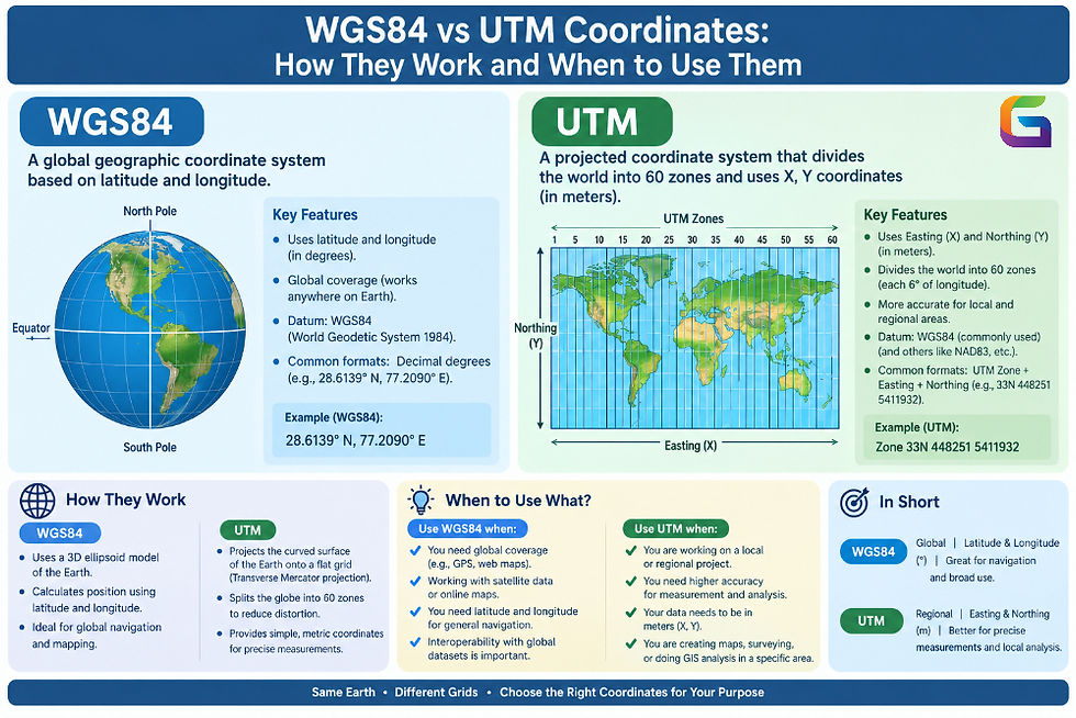
Effective GIS analysis highly relies on the selection of credible coordinate reference systems (CRS).
ArcGIS Pro incorporates both geographic coordinate systems and projected coordinate systems, giving users the ability to convert datasets from one type of coordinate system to another.
The key ideas include:
Geographic coordinate systems
Projected coordinate systems
Datum
Map projections
EPSG codes
Spatial reference
Coordinate transformations
For example, latitude/longitude units could be recorded through a geographic coordinate system, while engineering and mapping applications could utilize a projected coordinate system in meters or feet.
Python Integration
ArcGIS Pro supports Python-based GIS workflows through ArcPy.
Python can be used to automate geoprocessing, manipulate GIS datasets, execute spatial analysis tools, and build customized workflows.
A typical automated workflow may involve:
Load GIS data
      ↓
Validate spatial reference
      ↓
Process datasets
      ↓
Perform spatial analysis
      ↓
Generate outputs
      ↓
Export results
Python automation is particularly useful for large datasets and repetitive GIS processing tasks.
Integration With Geospatial Data Formats
With regard to spatial data types and formats, ArcGIS Pro is compatible with a plethora of different data formats and sources.
Some common formats are:
Being able to use many data formats allows analysts to develop seamless GIS processes that rely on various data types.
ArcGIS Pro for Change Detection
Change detection refers to the process of comparing the geospatial data collected over time.
The rudimentary steps may be:
Gathering imagery data from different dates.
Making sure that the spatial reference and resolution are the same.
Preprocessing the data.
Comparing data with respect to spectral and spatial features.
Classifying the areas where changes occurred.
Presenting and quantifying the results.
The change detection process may be used for assessing the impact of wildfires, monitoring deforestation, studying urbanization, flood mapping, or monitoring agricultural processes.
ArcGIS Pro vs Traditional GIS Workflows
Classic GIS workflows require using various software applications to perform data conversion, processing, visualization, and analysis. ArcGIS Pro incorporates some of these functionalities into a unified desktop platform.
A standard solution in the modern geospatial workflow includes:
Satellite imagery + LiDAR + vector data + elevation models + attribute data + spatial analysis
Incorporating all these tools allows GIS specialists to study complex spatial relationships and achieve better geographic analysis.
ArcGIS Pro is another highly developed, productive environment for GIS mapping, geospatial data management, spatial analysis, remote sensing, 3D visualization, and workflow automation. It integrates vector, raster, LiDAR, geoprocessing, spatial statistics, and Python, which makes it accommodating to a wide variety of professional GIS applications.
ArcGIS Pro encompasses the entire lifecycle of geospatial data, from creating simple maps to analyzing satellite images, doing terrain and geodatabase analysis, and building automated spatial workflows.
As GIS now widely utilizes satellite images, drone data, LiDAR, cloud-based datasets, artificial intelligence, and spatial analysis, tools such as ArcGIS Pro are essential in transforming complicated geospatial datasets into valuable spatial information.
For more information or any questions regarding ArcGIS Pro, please don't hesitate to contact us at:
Email:
USA (HQ): (720) 702–4849


Comments