
WGS84 vs UTM Coordinates: How They Work and When to Use Them

The accuracy of geospatial data relies on coordinate systems to locate locations on Earth. Two of the most frequently encountered coordinate systems in GIS, Surveying, GPS, Mapping and Remote Sensing are WGS84 and UTM. Although these systems are often discussed together, they differ in important ways.
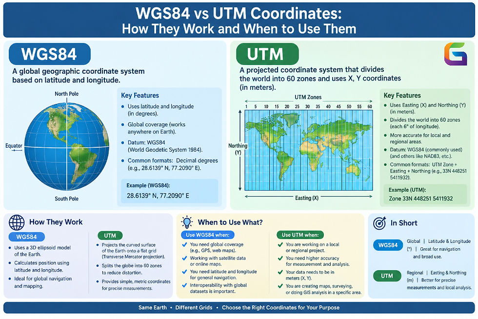
WGS84 (World Geodetic System of 1984) is an internationally recognized geodetic reference system used by GPS satellites and satellite-based positioning systems. The coordinates obtained using WGS are based on latitudes and longitudes, whereas UTM (Universal Transverse Mercator) is a projected coordinate system in which the Earth is divided into several zones and the coordinates in that system are measured in meters rather than degrees.
Being aware of WGS84 and UTM coordinates will help you when working with satellite images and aerial photos, in drone mapping, using LiDAR data, working with other GIS datasets, measuring data using GPS, and performing spatial analysis.
What Is WGS84?
The World Geodetic System (WGS) 1984, also known as WGS84, is a globally recognized geodetic reference system that allows for the indication of points on the Earth’s surface. WGS84 represents the basis of geographic coordinates like latitude and longitude.
WGS84 is often linked with GPS, as the modern GPS navigation system relies on the WGS84 system for positioning.
Usually, WGS 84 is expressed as follows:
Latitude – the position north or south of the Equator
Longitude – the position east or west of the Prime Meridian
For example:
Latitude: 40.7128° N
Longitude: 74.0060° W
This helps to identify New York City.
WGS84 National Format
About the WGS84 geodesic coordinates, they may be represented in one of the systems below:
Decimal degrees (DD)
Degrees, minutes, and seconds (DMS)
Degrees with decimal minutes (DDM)
Typically, decimal degree representation is popular in modern GIS systems and web mapping.
WGS84 coordinates should be identified with EPSG:4326 if the 2D geographic coordinate system is concerned.
What Is UTM?
UTM, or Universal Transverse Mercator, is a type of coordinate system that utilizes a grid to depict locations across the Earth’s surface.
Unlike the latitude-longitude framework employed to locate spots on the surface, UTM uses the following:
Easting
Northing
UTM zone
The measurements are calculated in meters (m) as a standard.
An example of a UTM coordinate will be written like:
Easting = 583,960 m
Northing = 4,507,350 m
Zone = 18N
The numbers change according to where the location is and what UTM zone it belongs to.
How Does the UTM Coordinate System Work?
The UTM coordinate system is composed of the Earth divided into 60 zones.
Each zone extends for 6° in terms of longitude.
The designations of the zones are from 1 to 60, starting from 180° west longitude towards the east.
Each zone uses a specific Transverse Mercator projection, which enables every zone to have its own projection, minimizing distortion in that zone rather than relying upon a single projection that depicts the whole planet.
The divisions do exist for the Northern Hemisphere and the Southern Hemisphere.
For example:
18N = Zone 18, Northern Hemisphere
18S = Zone 18, Southern Hemisphere
Therefore, typical UTM coordinates consist of the following elements – zone + hemisphere + easting + northing.
Having just easting and northing may lead to confusion without revealing the correct zone location.
WGS84 vs UTM: Key Difference
The biggest difference between WGS84 and UTM is how geographic locations are represented.
Feature | WGS84 | UTM |
Coordinate type | Geographic | Projected |
Common coordinates | Latitude/Longitude | Easting/Northing |
Units | Degrees | Meters |
Global coverage | Yes | Divided into 60 zones |
Common use | GPS and global positioning | GIS, surveying, engineering |
Distortion | Angular/geographic representation | Controlled within each zone |
Common EPSG example | EPSG:4326 | EPSG:326xx / EPSG:327xx |
It needs to be recognized that WGS84 and UTM are not merely rival systems. WGS84 can act as the Earth reference system while UTM gives the effective way of representing coordinates using a specific reference frame and zone.
WGS84 and UTM in GIS
It is important to understand that coordinate reference systems are very important in GIS because they can vary for various datasets.
To illustrate this, we can take advantage of various examples. Among them are:
GPS points in WGS84
Aerial imagery in a UTM projection
LiDAR data in a local projected CRS
Road data in a state or national coordinate system
Web maps using Web Mercator
Any popular GIS software (ArcGIS Pro, QGIS, Mapper, and other similar solutions) can help with CRS transformation of the data.
When Should You Use WGS84?
WGS84 is mostly applicable in cases where a global reference system of geography is needed.
Examples of typical usage include:
GPS Data
GPS receivers usually provide latitude and longitude based on WGS84.
This is relevant for the following purposes:
Tracking with GPS
Navigation
Field data gathering
Location-based services
Mobile mapping
Global Mapping
WGS84 is also good for applications with extensive geographic coverage and even worldwide scope.
For example, WGS84 could apply to a global database of cities, countries, and GPS observations.
Satellite and Remote Sensing
A number of satellite data sets employ geographic coordinate reference systems or projected coordinate reference systems that are based on WGS84 or some other geodetic datum.
When processing satellite images, do not forget to verify the metadata of the data set to confirm that it is using WGS84.
Web and Location-Based Applications
The usage of latitude and longitude helps to easily transfer location data between various systems.
For example:
Latitude: 34.0522
Longitude: -118.2437
This type of information can be easily stored in databases, APIs, CSV files, and other location-based applications.
When Should You Use UTM?
UTM is most suitable for local and regional datasets where distances should be calculated in meters.
Surveying
The surveyor is expected to obtain information about distances, areas, and coordinates in metric units.
With its projected coordinate system, UTM enables efficient measurement calculations in the relevant zones.
Drone Mapping
Drone mapping and photogrammetry generate data that often needs to be measured in terms of distances and areas with high precision.
Useful applications of UTM include:
Orthophotos
Control points
Survey measurements
To choose the best CRS, it is necessary to consider the location and accuracy needed for the project.
Engineering and Construction
In construction and engineering projects, local cross-sectional units are mostly used instead of global latitude/longitude coordinates.
With the use of projected coordinate systems, like UTM, the following become much easier:
Borders of the site
Distance
Area
Elevation
Any other information related to the infrastructure
GIS Spatial Analysis
Operational procedures involving GIS work better within projected coordinate systems in case of various analyses related to distances, areas, buffers, etc.
For example, it is easier to create a buffer of 500 meters in a projected coordinate system than in a geographic coordinate system.
Converting WGS84 to UTM
GIS software can transform WGS84 latitude/longitude coordinates into the appropriate UTM zone.
For example:
WGS84
Latitude: 40.7128
Longitude: -74.0060

        ↓ Coordinate Transformation

WGS84 / UTM Zone 18N

Easting: 583, xxx m
Northing: 4,507, xxx m
Zone: 18N
The exact UTM values depend on the projection parameters and coordinate reference system used.
Important Consideration
Do not convert coordinates simply by changing the labels from latitude/longitude to easting/northing.
A proper coordinate transformation or projection operation is required.
WGS84 Vs. UTM in Satellite Images
When handling satellite images, coordinate reference systems play an important role.
A satellite image carries information that includes the following:
CRS details
Datum
Projection type
EPSG code
Size of pixel
Geotransform process
Coordinates of the image
Information about the ground reference
If you mix satellite imagery with vector layers, altitude data, road details, and GPS coordinates, you have to deal with the respective coordinate reference systems appropriately.
If there is a discrepancy between them, some datasets may look shifted or misaligned.
For example, when GPS is recorded using the WGS84 coordinate system and the satellite layer uses another projection system, one of the layers should be transformed in order for GIS software to work correctly.
WGS84 vs UTM for Drone Data
When it comes to drone mapping, there are more things to think about, as the use of high-resolution pictures needs accurate spatial references.
The usual workflow of drone mapping is more or less as follows:
Take aerial pictures.
Get GPS or GNSS data.
Carry out image processing using software for photogrammetry.
Create an orthomosaic or point cloud.
Select a proper CRS.
Export the obtained products.
Process the data with GIS software.
When looking at a small-scale project, an appropriate UTM zone can be considered.
But for large-scale projects, the appropriate CRS should be chosen based on survey control by means of surveying, datum, geoid model, local rules, and required accuracy.
Both WGS84 and UTM coordinates are key to modern geospatial activity, but they serve different functions. The geographic coordinates of WGS84 offer a worldwide latitude/longitude framework, whereas UTM utilizes a zone-based projected coordinate system measured in meters.
When it comes to GPS positioning or global location sharing, choosing WGS84 latitude/longitude is typically a smart option. In contrast, when the work involves local mapping, regional planning, drone mapping work, and GIS analysis that is based on measurements, the most suitable choice is to adopt the corresponding UTM zone.
The most significant criterion is not to choose between WGS84 and UTM but to select the best-fitting coordinate reference system according to your specific geographic extent and data source, along with measuring modalities and the level of desired accuracy.
For more information or any questions regarding WGS84 and UTM Coordinates, please don't hesitate to contact us at:
Email:
USA (HQ): (720) 702–4849


Comments