
Satellite Imagery Resolution
Satellite imagery resolution describes the level of detail visible in images captured by Earth-observing satellites. It determines how clearly objects and features on the Earth's surface can be identified and analyzed. The most significant factor affecting image quality is spatial resolution, which represents the size of the ground area covered by a single pixel. Higher spatial resolution means each pixel represents a smaller area, allowing finer details such as buildings, roads, vehicles, and vegetation to be distinguished. These images are widely used in urban planning, infrastructure development, disaster management, environmental monitoring, and defense. Lower spatial resolution images cover larger areas with fewer details, making them ideal for studying broad geographic patterns, including forest cover, agricultural landscapes, weather systems, ocean conditions, and long-term land-use or environmental changes.
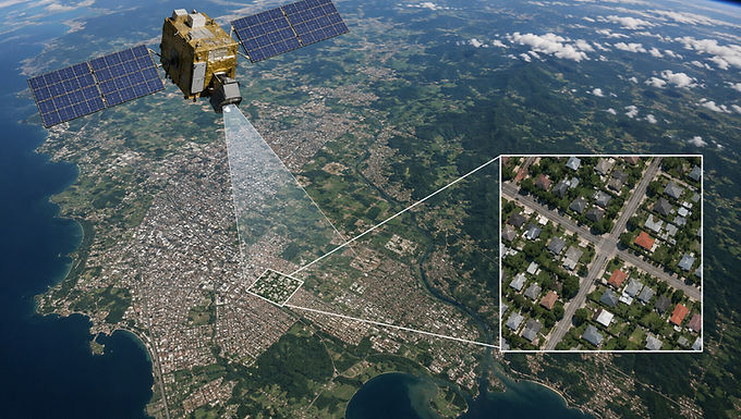
Satellite imagery resolution is determined by factors such as the sensor type, the satellite’s orbital altitude, and the imaging technology it uses. Higher-resolution imagery captures finer details of the Earth's surface, while lower-resolution imagery covers larger areas with less detail. Modern commercial satellites can produce sub-meter resolution images, making it possible to identify individual buildings, roads, vehicles, and other small features. These highly detailed images are valuable for applications including urban planning, infrastructure monitoring, defense, disaster management, and emergency response, where precision is critical. Medium-resolution imagery provides a balance between detail and coverage, making it suitable for land-use mapping, agriculture, forestry, and environmental monitoring. Low-resolution imagery offers extensive geographic coverage and is commonly used for climate research, weather observation, vegetation analysis, and tracking large-scale environmental changes. Selecting the appropriate resolution depends on the project's objectives, required level of detail, and the area being studied.
For more information or any questions regarding our services, please don't hesitate to contact us at
Email: info@geowgs84.com
USA (HQ): (720) 702–4849
India: 9009471866 - Jay Sharma
Canada: (519) 590 9999
Mexico: 55 5941 3755
UK & Spain: +44 12358 56710