
Airborne LiDAR
Airborne LiDAR (Light Detection and Ranging) is an advanced remote sensing technology that uses laser pulses emitted from aircraft, helicopters, or UAVs to accurately measure distances between the sensor and the Earth’s surface. The system records the time taken for each laser pulse to travel to the ground and return to the sensor, enabling the precise calculation of elevation, location, and surface characteristics. During a survey, millions of laser measurements are collected, generating dense point clouds that represent the three-dimensional structure of the landscape. These data are processed to create highly detailed and accurate 3D models of terrain, vegetation, buildings, infrastructure, and other surface features. Airborne LiDAR is widely used in applications such as topographic mapping, forestry management, urban planning, flood risk assessment, environmental monitoring, and infrastructure development due to its ability to capture high-resolution spatial information over large areas efficiently.
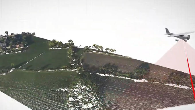
Airborne LiDAR (Light Detection and Ranging) is a highly advanced remote sensing technology widely used in mapping, land surveying, forestry, urban planning, environmental monitoring, and infrastructure development. Mounted on aircraft, helicopters, or drones, LiDAR systems emit laser pulses toward the Earth's surface and measure the time taken for the reflected signals to return, generating highly accurate three-dimensional spatial data. One of its most significant advantages is its ability to penetrate gaps in vegetation canopies, allowing the detection of ground elevations beneath dense forests. This capability enables the creation of precise Digital Elevation Models (DEMs) and Digital Terrain Models (DTMs), which are essential for terrain analysis and land management. Airborne LiDAR supports rapid and efficient data acquisition over large areas with exceptional accuracy and detail. It is extensively used for flood risk assessment, watershed management, infrastructure planning, transportation corridor mapping, resource management, and disaster mitigation. Additionally, it helps identify subtle landforms, monitor environmental changes, and improve decision-making processes in both urban and natural environments, making it an indispensable tool for modern geospatial applications.
For more information or any questions regarding our services, please don't hesitate to contact us at
Email: info@geowgs84.com
USA (HQ): (720) 702–4849
India: 9009471866 - Jay Sharma
Canada: (519) 590 9999
Mexico: 55 5941 3755
UK & Spain: +44 12358 56710